What Lies Around the Bend in Snake Gulch, Arizona
Curiosity is largely what has kept me coming back to Snake Gulch, Arizona, for well over a decade now. It is also what tends to get me in trouble every time. After reading countless online posts from others who have hiked the canyon, I have realized that I am not alone. It is the type of place that tends to reward those curious enough to hike around the next bend with another amazing rock art panel or form of wonderment. It is like a magnetic pull that draws you in, distorting time and distance in the process.
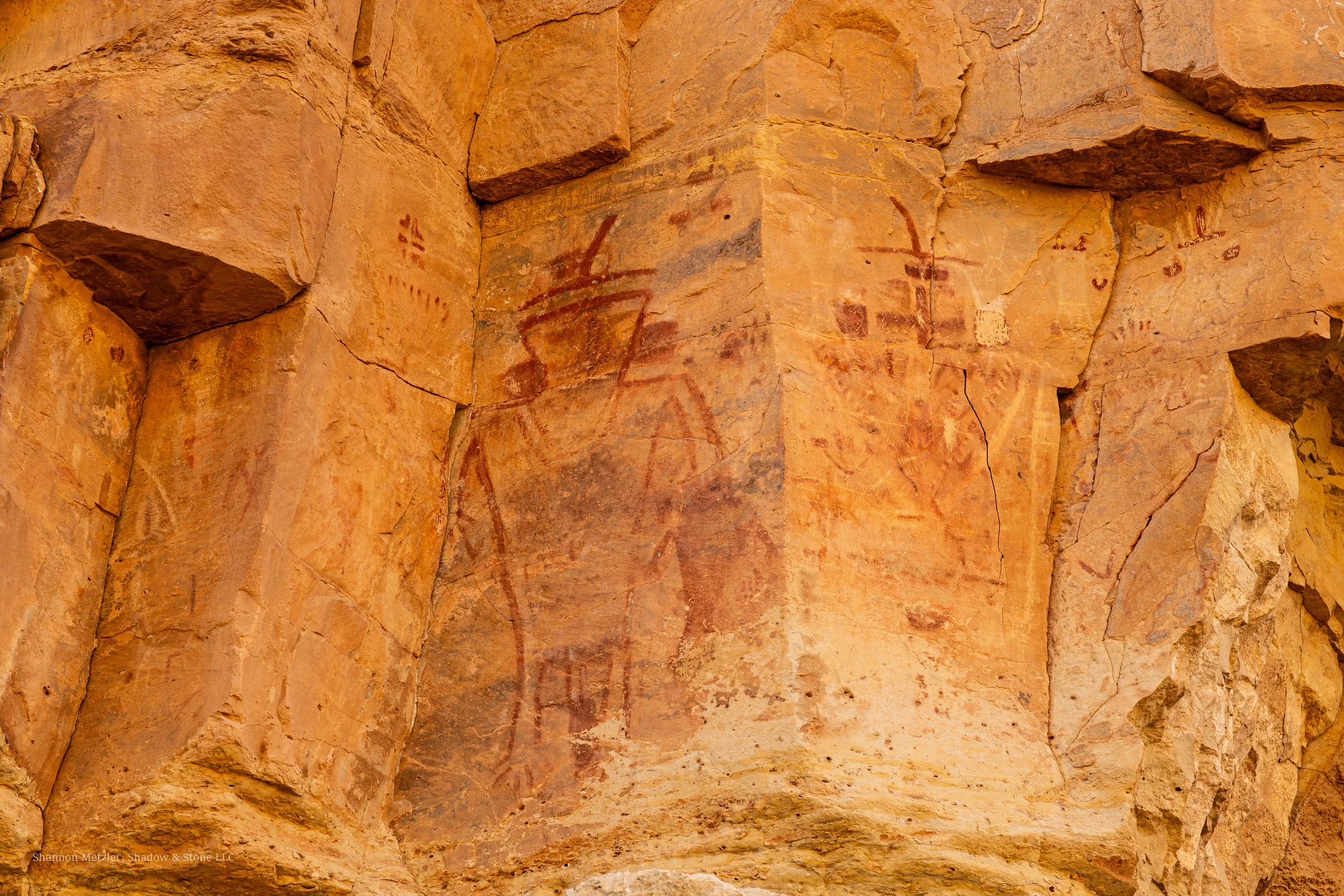
Snake Gulch (sometimes called Snake Creek) is a tributary of Kaibab Creek, which drains into the Colorado River in the Grand Canyon about 20 miles downstream from their confluence. For most, the allure of Snake Gulch is the colorful pictographs (painted) and petroglyphs (carved/pecked) that line the canyon walls. The canyon contains some of the most enigmatic and captivating rock art anywhere, including what some describe as "spacemen," which is largely what makes it so easy to keep hiking around the next bend. Many of the pictographs found in Snake Gulch do look otherworldly.
Curiosity about what lies beyond is a human story and has inspired people to venture across mountain ranges, deserts, grasslands, and oceans, beyond the horizon into the unknown. On the other hand, it is said that curiosity can have potential negative consequences as well. The saying, "Curiosity killed the cat,” suggests curiosity is not always a good thing. Indeed, curiosity has gotten me in trouble on more than one occasion. But most people are less familiar with the full saying, “Curiosity killed the cat, but satisfaction brought it back," which suggests the satisfaction of coming to know the answer makes the risk worthwhile. As with any hike or outdoor activity, there are also risks of injury and potential harm (disclaimer) that come with venturing around the next bend.
Snake Gulch, Az.
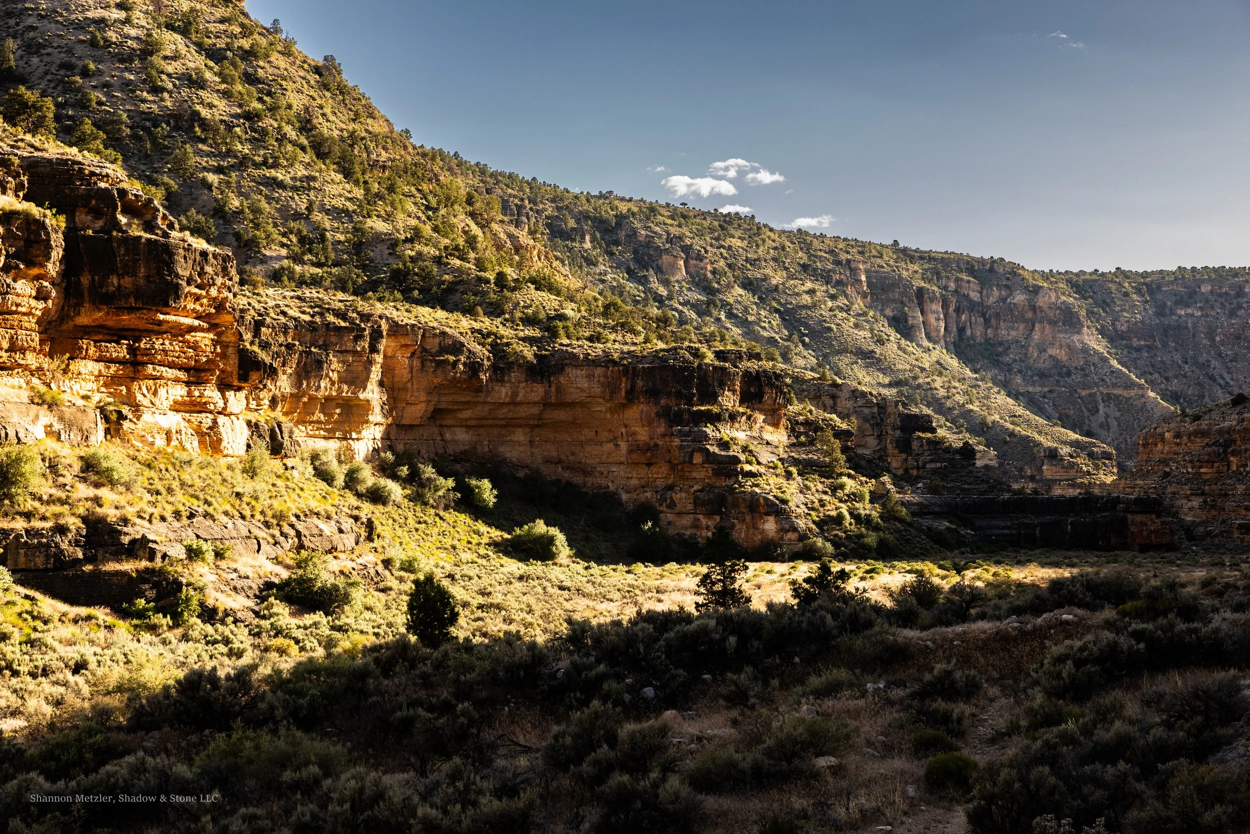
Snake Gulch is not the most dramatic or colorful canyon in the area, but it is still incredibly beautiful, especially at sunset, when the canyon walls' orange, beige, and red tones glow in the setting sun. I would imagine the sunrise is also very beautiful, but I have never been there in the morning. It is also one of the quietest places I have hiked, with less flight traffic than other locations on the Colorado Plateau. Furthermore, I have never encountered another person or group on the trail during my four visits there. Wildlife movement occasionally breaks the silence, or me, after finding another cool panel.
Most pictographs were made by the Basketmaker people who inhabited the area from about 300 BC to 800 AD. The rock art of Snake Gulch reflects multiple cultural groups and time periods, with most pictographs estimated at 1200 to 3000 years old and most petroglyphs believed to have been made by the Southern Paiute people between 700 and 1600 AD. The rock is believed to represent the Basketmaker, Fremont, and Southern Paiute peoples primarily.
My first trip to Snake Gulch almost fifteen years ago was in late December. The temperatures were still in the 40s to low 50s during the day, but dropped well below freezing at night. The plan was to walk about two miles down the canyon and be out in a couple of hours. We ended up walking closer to 3+ miles and came out as the last of the daylight was all but gone. It was the allure of so much rock art and the curiosity about what lay around the next bend in the canyon that led to the extra distance, and why we just barely made it back to the trailhead without needing headlamps. This played out on the second and third trips as well, but on the most recent trip, well, there was a little over an hour of walking in the dark before getting back to the trailhead, but that was intentional.
On my second-to-last trip in late April of 2026, I had a simple goal: hike about 3 miles to what I call the “alien pictograph,” and photograph it with significantly better camera gear than I have had on any previous visit. I was still recovering from a recent 30-mile backpacking trip in the Grand Gulch just a week earlier, which is why I was trying to make up for abandoning my dog, Siytka, for a week by getting him out for a good run.
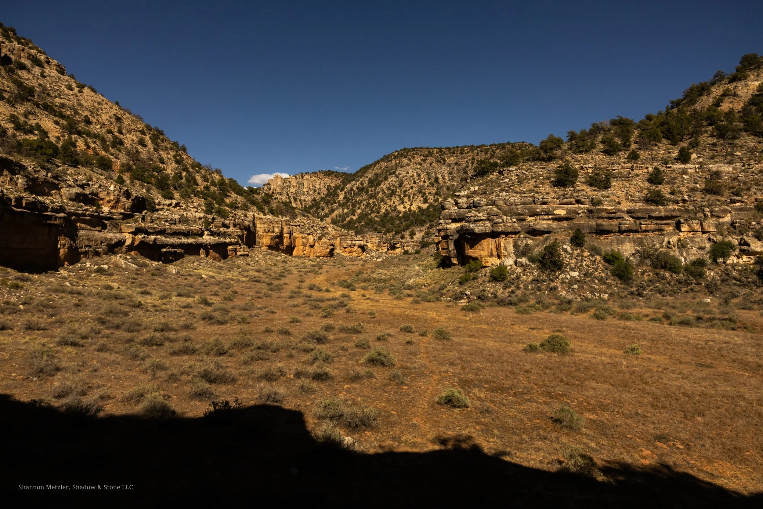
Snake Gulch has a significantly lower gradient than Grand Gulch, dropping just under 700 ft in about 7 miles, which is roughly the distance to Table Rock, a popular destination because of the large concentration of rock art and a few remnants of ancient masonry walls, likely once granaries. The miles seeming to go by fast on the way in is another familiar experience in Snake Canyon. I can’t say the same is true on the way out. But this time, they seemed to go by faster than ever, perhaps as a result of my recent adventures in lower Grand Gulch.
The trailhead sits at around 5850 feet, similar to the average canyon-bottom elevation in Grand Gulch (5500 feet). The trail is generally easy to follow and has no real obstacles to navigate, other than crossing the wash a couple of times and sections where weeds and grass overgrowth obscure the path. This largely depends on foot/hoof traffic and how many people and horses have used the trail recently.
With near-perfect hiking temperatures but limited light, I decided to pass a couple of rock art sites, intending to revisit them on our return. I scanned the canyon wall for the panel as I rounded bend after bend. I felt confident I would get there with enough daylight to take photos, despite starting in late afternoon and with only about 4 hours before sunset.
I knew I was making good time, but I grew more nervous when I didn't see the panel after I probably should have. I started to consider that I might have made much better time than I had realized, and that I could have already walked past the panel. After pausing to look around and assess the situation, I decided to continue until I could see around the next bend, and I would just turn around if I still did not see the panel or something that could help me determine where I was. One bend turned into another, and a short time later, I found myself another half mile down the canyon staring at a panel I recognized from a previous trip five years earlier. A feeling of both dread and excitement came over me. I knew where I was at that moment, and I knew that I had walked well past my intended destination. I had walked more than 4.5 miles in a little less than an hour and a half, and was at least a mile and a half past my intended destination.
With his tongue hanging out, panting, Siytka moved into some shade and flopped to the ground. It was obvious that we both needed a break, so we stopped for a moment as I took stock of our situation and carefully poured some water into his bowl. Siytka quickly lapped it up, and it became apparent that water would be the main issue, since I had intended to be out for less than a couple of hours and had packed a little over a liter. I knew better and should have anticipated that we would be out longer. I decided I would drink as little as possible. After all, it was not his fault we were in that situation. We still had a good amount of water and would make a beeline back to the alien panel, rest there again, then make for the trailhead.
We rested for a few minutes before I explored the area, making sure to go just a little farther down the trail than I had been and hoping to see what was just around the next bend. It was a large alcove that looked perfect for habitation. I did not have time to explore it, but I suspected that I was close to Table Rock, given what I had read about the canyon. After taking a few photos, we started back up the canyon and made good time. We arrived at the “alien pictograph” just before sundown. I had brought some lighting gear to capture some low-light photographs I had intended to take anyway. In the end, it all worked out. We still managed to make it to the trailhead just as it got dark enough to need headlamps. We still had a small amount of water, but were pretty exhausted after hiking about 10 miles in a little over 4 hours.
Another familiar experience is arriving back at the car fairly depleted. I always seem to feel a deep sense of satisfaction, despite the exhaustion and near-uncontainable excitement that come with the anticipation of setting my aching feet free. I tend to always follow the rule: either have a good amount of water in the vehicle for after a hike, or don't do the hike. As in this outing, it is always a relief to be able to drink as much water as needed, which helps lower the potential impact of dehydration. We returned with some water, but knowing there is water in the car can be a great motivator to keep “truckin'“ down the trail. Most importantly, it ensures you have water on hand in case of a mechanical issue that prevents you from leaving. I have seen one other vehicle pull in and immediately leave the trailhead the four times I have been there.
The Land and Respect
The land has long been considered sacred by numerous indigenous groups who still live in the area today. Some still come to Snake Gulch for ceremony and connection. The rock art and remnants of cliff dwellings should never be touched by hand or other means. The few remaining walls of the ancient structures should serve as an indicator of their fragility. Oils on hands damage rock art, on top of the potential damage from just touching natural paint that is hundreds, even thousands, of years old. Snake Gulch is a sacred place to many and a world-class rock art site that deserves our respect and our efforts to preserve it for future generations. Should you decide to go there after reading this post or otherwise, it is your responsibility to give others the same opportunity and experience you get to have.
Getting There
The Snake Canyon Trailhead is located in a remote wilderness area in the Arizona Strip, where there is no cell phone service. I let people know specifically where I am going and what I have planned for my furthest destination. I also establish a specific check-in time, so someone knows pretty quickly if something has gone wrong. It is usually an expected time I will be out and back to service, and the latest time I will check in, perhaps by 10 am the following morning, which establishes when authorities should start being contacted. I can also communicate via satellite, as long as the device has power, a satellite connection, and is working properly.
To get to the trailhead from Fredonia, Arizona, drive south of town on Highway 89-A and turn right on Forest Service Road 22, and follow FR 22 for approximately 20.9 miles before the road becomes Ryan Rd/West Side Rd. Continue on Ryan Rd/West Side Rd for 2 miles. The pavement on FR 22 is not well-maintained and contains numerous stretches of potholes before it ends after about 21 miles, then transitions to a maintained gravel road. I preferred the dirt road over the pavement on the last two visits. Turn right onto FSR 423 and continue for another 2 miles, then turn right again onto FSR 642; it is another 2.5 miles to the trailhead. It takes about 50 minutes to get to the trailhead once you leave Highway 89-A. The trailhead has a couple of information kiosks and a trail register. There is a turnaround that is important not to block, which can make it difficult to avoid parking in dry grass and vegetation that can ignite from hot car exhaust systems. Keep this in mind during dryer periods. Camping can also be challenging for this reason, but there is also little chance of seeing much traffic at the trailhead.
I have read several posts saying you need a high-clearance four-wheel drive to reach the trailhead. I have taken a low-clearance all-wheel-drive vehicle out to the trailhead the last two times without any problems. I did not need all-wheel drive, but there were a few places where I had to be careful with the low ground clearance. Moderate to heavy rain could easily make the road impassable for a time, and the road was nearly washed out in a few places after flash flooding in 2025. The burn scar above Snake Creek on the Kaibab Plateau will continue to present some flood risks until the land recovers from the massive 2025 fire. Again, a good reason to travel with extra water and food. Certainly, a high-clearance four-wheel- or all-wheel-drive vehicle is preferable when traveling in this region.
The Trail
The trail is relatively easy to follow, especially the upper sections, where it is more worn. There are no real tributary canyons until Table Rock, which is about 6.5 to 7 miles from the trailhead. Getting lost is generally not a concern if one pays attention to their surroundings. The trail extends about 21 miles in total before its confluence with Kanab Creek. It is a good idea to have a map or GPS, especially if you are unfamiliar with the area. In a few relatively short areas, the trail passes close to deep washes where a fall would be bad. Again, not a big deal if one is paying attention and being intentional about where they step, which is important anyway. It is always best to be on the lookout for snakes, especially in late spring, summer, or fall. Long pants or gators are recommended due to the vegetation lining the trail, which can take a toll on legs. Despite always wearing long pants, I get foxtails and other debris in my hiking shoes every time. The trail is relatively flat and generally clear of rocks, but it always seems to take a surprising toll on the feet. Good footwear and taking the time to tape up problematic areas can go a long way toward avoiding blisters and reducing overall impact.
Water & Food
I have always brought all the water I would need for my hikes in Snake Gulch, though, as we have established, I sometimes underestimate that amount. That is because I knew the springs would likely be dry when I went, and I was not planning to hike back to a spring or Table Rock Canyon, where there is a more reliable spring. Still, I have read numerous reports from people who ventured to Table Rock Spring only to find it dry. Unless you are confident a spring is flowing, I would plan to carry all the water you might need, which is recommended to be about 1 gallon (3.8 liters) per day. I would also plan to bring snacks and food for day hikes, as they help maintain energy, especially when it is particularly hot or cold.
Times of the year and hiking Snake Gulch
Let's just start with the least ideal time to try to hike the canyon, summer. The temperatures in this area can soar well above 100 degrees in the summer, and the canyon has virtually no shade to find relief from the sun. It is possible to hike very early or very late to avoid the heat and sun, but that also means you will likely need to hunker down in the shade at times until things improve. Not necessarily ideal, but it can work.
Winters can be challenging due to snow and ice, which can make roads dangerous or even impassable for short periods. As I mentioned earlier, my first trip to Snake Gulch was in late December, and I had no trouble reaching the trailhead despite a few inches of snow on the road in some places. But I had also checked the weather forecast and was confident we would not have any additional snow coming during our trip. I was also prepared to turn around if the roads were bad.
Late March through late May or mid-September through late October are probably the best times to explore Snake Canyon. The shoulders of these times can also be ideal, but the weather patterns are more varied, which makes checking the forecast all the more important. I would not want to get caught down the trail during an unexpected temperature swing to either extreme. Always checking the forecast before you go also ensures you are prepared for potential storms, especially flash floods or snowstorms, which could significantly slow your pace and make the road impassable.
Table Rock also serves as a destination for backpackers. There are remnants of old campfires, some just below rock art sites. Do not build fires near rock art, no matter where you decide to camp. Avoid camping in front of the alcove of “Big Panel” and the cliff dwelling. There is a more frequently used campsite just below the point at Table Rock that is better suited for low-impact camping. Overgrowth from the grass can be an issue for camping and fires.
I have never seen bears or bear signs in Snake Gulch, but it seems prudent to be aware of the possibility, especially at the trailhead and Table Rock. This is another reason why low-impact camping is important. Pack your trash out and be careful to not leave food at campsites. It is a canyon well-suited for cougars and coyotes, but dry conditions and a lack of water could make that less so. Signs of deer and bighorn sheep are more prevalent. Where there is prey, there are likely predators.
Bringing Pets, Young Kids, and Final Thoughts
On my most recent trip, I returned to Snake Gulch at the end of May in 2026. The temperature was going to be in the low 70s, and it seemed like one more opportunity to hike down Snake Gulch before the summer temperatures arrive. But the temperature and midday sun exposure still proved too much for Siytka, so we stopped after a little more than 2 miles and spent more than an hour in a shaded alcove. We also had enough water to help him rehydrate, which allowed him to recover enough for us to reach the Table Rock area once the sun was less of an issue.
It is getting harder to find trails where I can hike with Siytka. Snake Gulch is a great place to bring dogs, but there are hazards to consider, such as rattlesnakes that come out to hunt small rodents near cliffs, especially in the evening. It is also important not to allow dogs to dig in alcoves and around the remnants of cliff dwellings. Rodents have been known to carry hantavirus in this region, and the risk increases in alcoves and in areas like cliff dwellings where they can make homes. As dog owners, we should be mindful of the potential impact our dogs might have and take steps to minimize it by doing things like removing their poop from trails, springs, and ancient sites, and making sure they do not attack wildlife or people.
I took my kids to Snake Gulch when they were around 10 and 14 years old. Though the hiking is fairly easy, I would not recommend bringing kids much younger than 10, primarily due to sun exposure, lack of shade, and the distance required to reach most of the rock art sites. The first rock art site is in an alcove just past the first wash crossing, around 2.5 miles from the trailhead, and could make for a good shorter hike for younger kids on the right day. Still, that is 5 miles round trip and may require a little piggybacking to get them to and from the site.
Snake Gulch is generally considered an easy hike, but I have found that the terrain can still take a surprising toll on feet, especially after a group of horses has recently gone down the trail. It is mostly loose and packed sand with sections of long grass. Weather, temperatures, and sun exposure are the factors that tend to have the most impact on people and dogs.
There is little doubt I will return to Snake Gulch in the future because there is more around the bend to see and explore. It is an amazing place that few people know about, well, for now. If you are a rock art junky like me, it is a place you should not miss. There is no other place like it.