
What Lies Around the Bend in Snake Gulch, Arizona
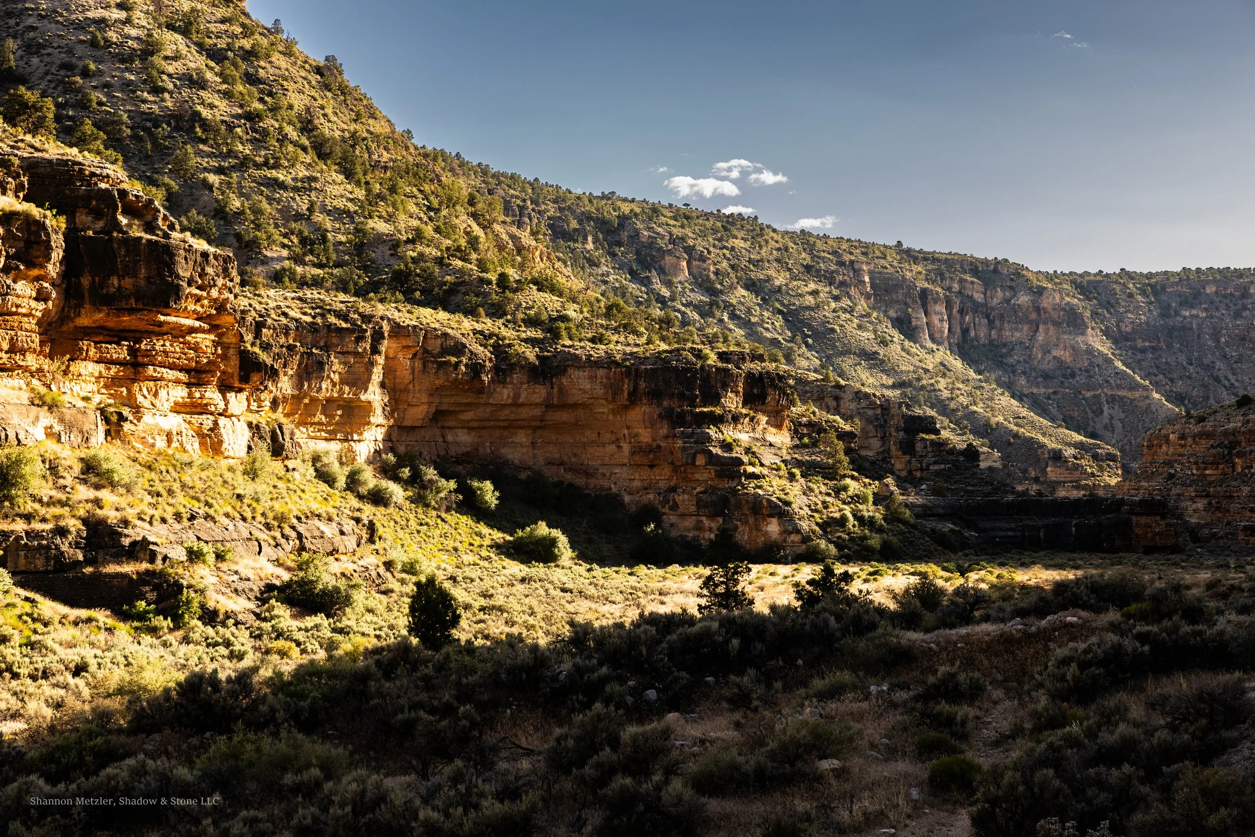
Curiosity is largely what has kept me coming back to Snake Gulch, Arizona, for well over a decade now. It is also what tends to get me in trouble every time. After reading countless online posts from others who have hiked the canyon, I have realized that I am not alone. It is the type of place that tends to reward those curious enough to hike around the next bend with another amazing rock art panel or form of wonderment. It is like a magnetic pull that draws you in, distorting time and distance in the process.
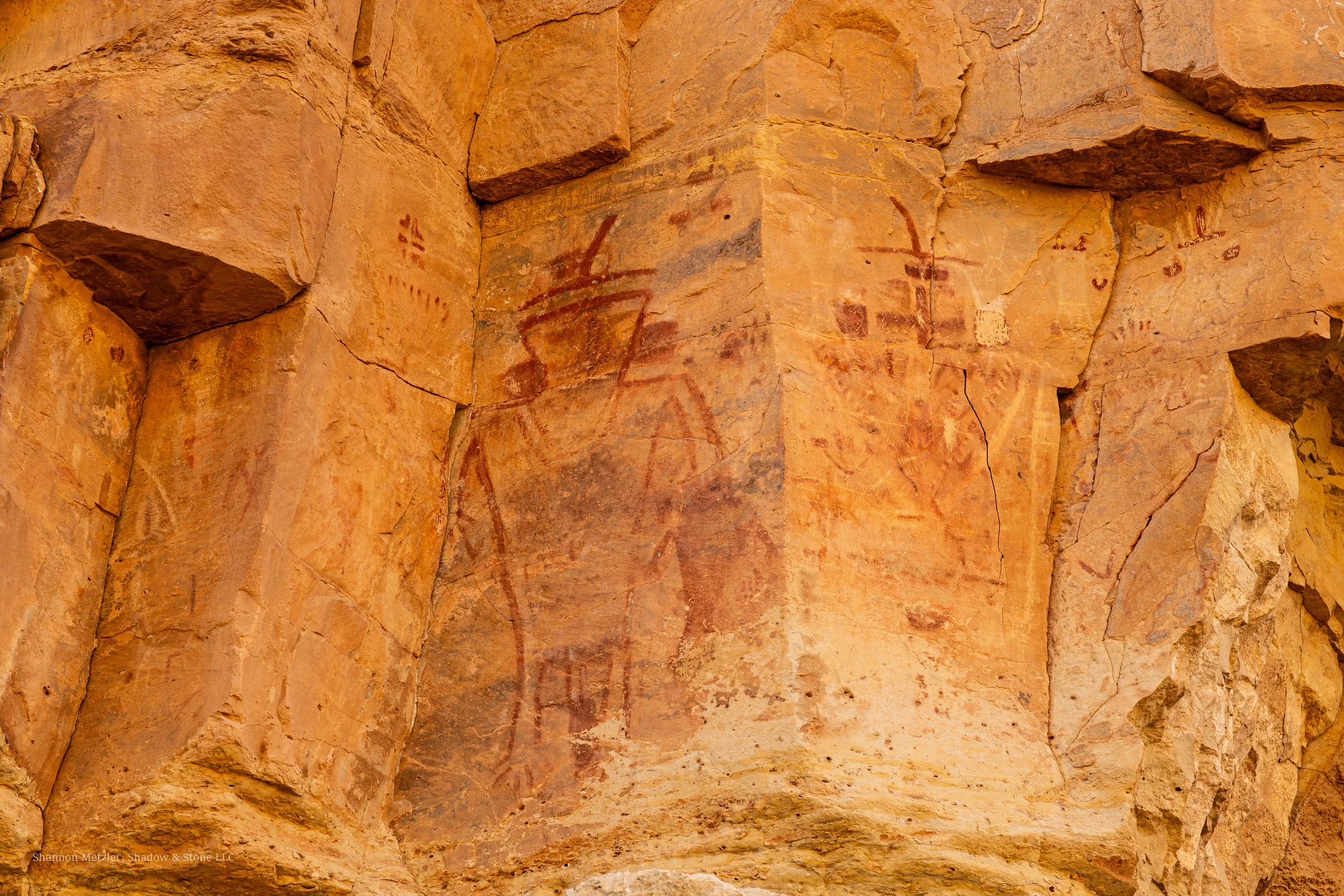
Snake Gulch (sometimes called Snake Creek) is a tributary of Kaibab Creek, which drains into the Colorado River in the Grand Canyon about 20 miles downstream from their confluence. For most, the allure of Snake Gulch is the colorful pictographs(painted) and petroglyphs(carved/pecked) that line the canyon walls. The canyon contains some of the most enigmatic and captivating rock art anywhere, including what some describe as "spacemen," which, if we are being honest, is largely what makes it so easy to keep hiking around the next bend. Many of the pictographs found in Snake Gulch do look otherworldly.
Curiosity about what lies beyond is a human story and has inspired people to venture across mountain ranges, deserts, grasslands, and oceans, beyond the horizon into the unknown. On the other hand, it is said that curiosity can have potential negative consequences as well. The saying, "Curiosity killed the cat,” suggests curiosity is not always a good thing. Indeed, curiosity has gotten me in trouble on more than one occasion. But most people are less familiar with the full saying, “Curiosity killed the cat, but satisfaction brought it back," which suggests the satisfaction of coming to know the answer makes the risk worthwhile. As with any hike or outdoor activity, there are also risks of injury and potential harm (disclaimer) that come with venturing around the next bend.
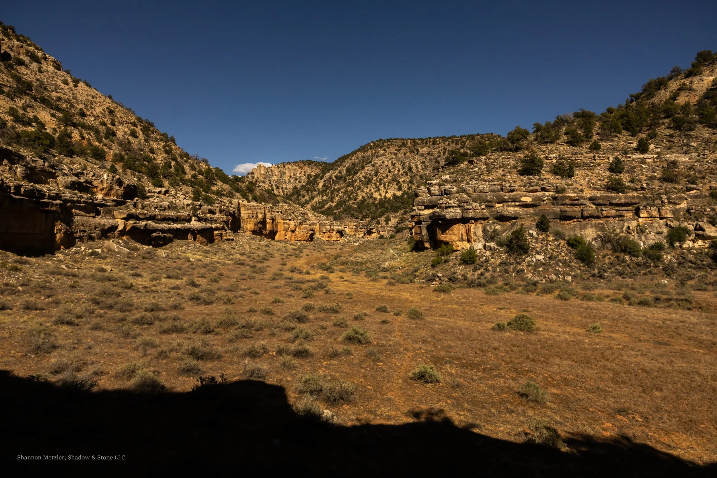
Snake Gulch, Az.
Snake Gulch is not the most dramatic or colorful canyon in the area, but it is still incredibly beautiful, especially at sunset, when the canyon walls' orange, beige, and red tones glow in the setting sun. I would imagine the sunrise is also very beautiful, but I have never been there in the morning. It is also one of the quietest places I have hiked, with less flight traffic than other locations on the Colorado Plateau. Furthermore, I have never encountered another person or group on the trail during my four visits there. Wildlife movement occasionally breaks the silence, or me, after finding another cool panel.
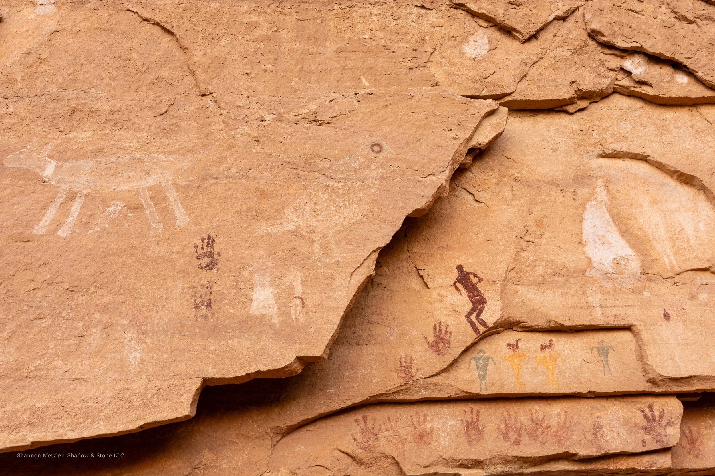
Many of the colorful pictographs were created by the Basketmaker people who inhabited the area from about 300 BC to 800 AD. But the rock art of Snake Gulch reflects multiple cultural groups and time periods, primarily the Basketmaker, Fremont, and Southern Paiute peoples. Most pictographs are estimated to be between 1200 and 3000 years old, and the petroglyphs are believed to have been created by the Southern Paiute people between 700 and 1600 AD.
My first trip to Snake Gulch almost fifteen years ago was in late December. The temperatures were still in the 40s to low 50s during the day, but dropped well below freezing at night. The plan was to walk about two miles down the canyon and be out in a couple of hours. We ended up walking closer to 3+ miles and came out as the last of the daylight was all but gone. It was the allure of so much rock art and the curiosity about what lay around the next bend in the canyon that led to the extra distance, and why we just barely made it back to the trailhead without needing headlamps. This played out on the second and third trips as well, but on the most recent trip, well, there was a little over an hour of walking in the dark before getting back to the trailhead, but that was intentional.
On my second-to-last trip in late April of 2026, I had a simple goal: hike about 3 miles to what I call the “alien pictograph,” and photograph it with significantly better camera gear than I have had on any previous visit. I was still recovering from a recent 30-mile backpacking trip in the Grand Gulch just a week earlier, which is why I was trying to make up for abandoning my dog, Siytka, for a week by getting him out for a good run.
Snake Gulch has a significantly lower gradient than Grand Gulch, dropping just under 700 ft in about 7 miles, which is roughly the distance to Table Rock, a popular destination because of the large concentration of rock art and a few remnants of ancient masonry walls, likely once granaries. The miles seeming to go by fast on the way in is another familiar experience in Snake Canyon. I can’t say the same is true on the way out. But this time, they seemed to go by faster than ever, perhaps as a result of my recent adventures in lower Grand Gulch.
The trailhead sits at around 5850 feet, similar to the average canyon-bottom elevation in Grand Gulch (5500 feet). The trail is generally easy to follow and has no real obstacles to navigate, other than crossing the wash a couple of times and sections where weeds and grass overgrowth obscure the path. This largely depends on foot/hoof traffic and how many people and horses have used the trail recently.
With near-perfect hiking temperatures but limited light, I decided to pass a couple of rock art sites, intending to revisit them on our return. I scanned the canyon wall for the panel as I rounded bend after bend. I felt confident I would get there with enough daylight to take photos, despite starting in late afternoon and with only about 4 hours before sunset.
I knew I was making good time, but I grew more nervous when I didn't see the panel after I probably should have. I started to consider that I might have made much better time than I had realized, and that I could have already walked past the panel. After pausing to look around and assess the situation, I decided to continue until I could see around the next bend, and I would just turn around if I still did not see the panel or something that could help me determine where I was. One bend turned into another, and a short time later, I found myself another half mile down the canyon staring at a panel I recognized from a previous trip five years earlier. A feeling of both dread and excitement came over me. I knew where I was at that moment, and I knew that I had walked well past my intended destination. I had walked more than 4.5 miles in a little less than an hour and a half, and was at least a mile and a half past my intended destination.
With his tongue hanging out, panting, Siytka moved into some shade and flopped to the ground. It was obvious that we both needed a break, so we stopped for a moment as I took stock of our situation and carefully poured some water into his bowl. Siytka quickly lapped it up, and it became apparent that water would be the main issue, since I had intended to be out for less than a couple of hours and had packed a little over a liter. I knew better and should have anticipated that we would be out longer. I decided I would drink as little as possible. After all, it was not his fault we were in that situation. We still had a good amount of water and would make a beeline back to the alien panel, rest there again, then make for the trailhead.
We rested for a few minutes before I explored the area, making sure to go just a little farther down the trail than I had been and hoping to see what was just around the next bend. It was a large alcove that looked perfect for habitation. I did not have time to explore it, but I suspected that I was close to Table Rock, given what I had read about the canyon. After taking a few photos, we started back up the canyon and made good time. We arrived at the “alien pictograph” just before sundown. I had brought some lighting gear to capture some low-light photographs I had intended to take anyway. In the end, it all worked out. We still managed to make it to the trailhead just as it got dark enough to need headlamps. We still had a small amount of water, but were pretty exhausted after hiking about 10 miles in a little over 4 hours.
Another familiar experience is arriving back at the car fairly depleted. I always seem to feel a deep sense of satisfaction, despite the exhaustion and near-uncontainable excitement that come with the anticipation of setting my aching feet free. I tend to always follow the rule: either have a good amount of water in the vehicle for after a hike, or don't do the hike. As in this outing, it is always a relief to be able to drink as much water as needed, which helps lower the potential impact of dehydration. We returned with some water, but knowing there is water in the car can be a great motivator to keep “truckin'“ down the trail. Most importantly, it ensures you have water on hand in case of a mechanical issue that prevents you from leaving. I have seen one other vehicle pull in and immediately leave the trailhead the four times I have been there.
The land and respect
The land has long been considered sacred by numerous indigenous groups who still live in the area today. Some still come to Snake Gulch for ceremony and connection. The rock art and remnants of cliff dwellings should never be touched by hand or other means. The few remaining walls of the ancient structures should serve as an indicator of their fragility. Oils on hands damage rock art, on top of the potential damage from just touching natural paint that is hundreds, even thousands, of years old. Snake Gulch is a sacred place to many and a world-class rock art site that deserves our respect and our efforts to preserve it for future generations. Should you decide to go there after reading this post or otherwise, it is your responsibility to give others the same opportunity and experience you get to have.
Getting there
The Snake Canyon Trailhead is located in a remote wilderness area in the Arizona Strip, where there is no cell phone service. I let people know specifically where I am going and what I have planned for my furthest destination. I also establish a specific check-in time, so someone knows pretty quickly if something has gone wrong. It is usually an expected time I will be out and back to service, and the latest time I will check in, perhaps by 10 am the following morning, which establishes when authorities should start being contacted. I can also communicate via satellite, as long as the device has power, a satellite connection, and is working properly.
To get to the trailhead from Fredonia, Arizona, drive south of town on Highway 89-A and turn right on Forest Service Road 22, and follow FR 22 for approximately 20.9 miles before the road becomes Ryan Rd/West Side Rd. Continue on Ryan Rd/West Side Rd for 2 miles. The pavement on FR 22 is not well-maintained and contains numerous stretches of potholes before it ends after about 21 miles, then transitions to a maintained gravel road. I preferred the dirt road over the pavement on the last two visits. Turn right onto FSR 423 and continue for another 2 miles, then turn right again onto FSR 642; it is another 2.5 miles to the trailhead. It takes about 50 minutes to get to the trailhead once you leave Highway 89-A. The trailhead has a couple of information kiosks and a trail register. There is a turnaround that is important not to block, which can make it difficult to avoid parking in dry grass and vegetation that can ignite from hot car exhaust systems. Keep this in mind during dryer periods. Camping can also be challenging for this reason, but there is also little chance of seeing much traffic at the trailhead.
I have read several posts saying you need a high-clearance four-wheel drive to reach the trailhead. I have taken a low-clearance all-wheel-drive vehicle out to the trailhead the last two times without any problems. I did not need all-wheel drive, but there were a few places where I had to be careful with the low ground clearance. Moderate to heavy rain could easily make the road impassable for a time, and the road was nearly washed out in a few places after flash flooding in 2025. The burn scar above Snake Creek on the Kaibab Plateau will continue to present some flood risks until the land recovers from the massive 2025 fire. Again, a good reason to travel with extra water and food. Certainly, a high-clearance four-wheel- or all-wheel-drive vehicle is preferable when traveling in this region.
Trail
The trail is relatively easy to follow, especially the upper sections, where it is more worn. There are no real tributary canyons until Table Rock, which is about 6.5 to 7 miles from the trailhead. Getting lost is generally not a concern if one pays attention to their surroundings. The trail extends about 21 miles in total before its confluence with Kanab Creek. It is a good idea to have a map or GPS, especially if you are unfamiliar with the area. In a few relatively short areas, the trail passes close to deep washes where a fall would be bad. Again, not a big deal if one is paying attention and being intentional about where they step, which is important anyway. It is always best to be on the lookout for snakes, especially in late spring, summer, or fall. Long pants or gators are recommended due to the vegetation lining the trail, which can take a toll on legs. Despite always wearing long pants, I get foxtails and other debris in my hiking shoes every time. The trail is relatively flat and generally clear of rocks, but it always seems to take a surprising toll on the feet. Good footwear and taking the time to tape up problematic areas can go a long way toward avoiding blisters and reducing overall impact.
Water
I have always brought all the water I would need for my hikes in Snake Gulch, though, as we have established, I sometimes underestimate that amount. That is because I knew the springs would likely be dry when I went, and I was not planning to hike back to a spring or Table Rock Canyon, where there is a more reliable spring. Still, I have read numerous reports from people who ventured to Table Rock Spring only to find it dry. Unless you are confident a spring is flowing, I would plan to carry all the water you might need, which is recommended to be about 1 gallon (3.8 liters) per day. I would also plan to bring snacks and food for day hikes, as they help maintain energy, especially when it is particularly hot or cold.
Seasonal considerations for hiking Snake Gulch
Let's just start with the least ideal time to hike the canyon: summer. The temperatures in this area can soar well above 100 degrees in the summer, and the canyon has virtually no shade to find relief from the sun. Sure, there may be an exception with weather patterns that make a summer hike possible. It is also possible to hike very early or very late to avoid the heat and sun, but that also means you will likely need to hunker down in the shade at times until things improve. Water and making good choices become potential life-and-death factors in the summer heat in this environment, which is why I would generally avoid it.
Winters can be challenging due to snow and ice, which can make roads dangerous or even impassable for short periods. As I mentioned earlier, my first trip to Snake Gulch was in late December, and I had no trouble reaching the trailhead despite a few inches of snow on the road in some places. But I had also checked the weather forecast and was confident we would not have any additional snow coming during our trip. I was also prepared to turn around if the roads were bad, as there is no real way of knowing some road conditions until you get out there.
Late March through late May or mid-September through late October are probably the best times to explore Snake Canyon. The shoulders of these times can also be ideal, but the weather patterns are more varied, which makes checking the forecast all the more important. I would not want to get caught down the trail during an unexpected temperature swing to either extreme. Always checking the forecast before you go also ensures you are prepared for potential storms, especially flash floods or snowstorms, which could significantly slow your pace and make the road impassable.
Table Rock also serves as a destination for backpackers. There are remnants of old campfires, some just below rock art sites. Do not build fires near rock art, no matter where you decide to camp. Avoid camping in front of the alcove of “Big Panel” and the cliff dwelling. There is a frequently used campsite just below the point at Table Rock that is better suited for low-impact camping. Overgrowth from the grass can make it difficult to find a clearing to camp and safely build fires.
I have not experienced bears or even seen signs of bears in Snake Gulch, but it definitely is bear country. This is another reason why low-impact camping is important. Packing your trash out and not leaving food at lunch stops helps avoid attracting bears and other animals.
Bringing pets and young kids.
On my most recent trip, I returned to Snake Gulch at the end of May in 2026. The temperature was going to be in the low 70s, and it seemed like one more opportunity to hike down Snake Gulch before the summer temperatures arrive. But the temperature and midday sun exposure still proved too much for Siytka, so we stopped after a little more than 2 miles and spent more than an hour in a shaded alcove. We also had enough water to help him rehydrate, which allowed him to recover enough for us to reach the Table Rock area once the sun was less of an issue.
It is getting harder to find trails where I can hike with Siytka. Snake Gulch is a great place to bring dogs, but there are hazards to consider, such as rattlesnakes that come out to hunt small rodents near cliffs, especially in the evening. It is also important not to allow dogs to dig in alcoves and around the remnants of cliff dwellings. Rodents have been known to carry hantavirus in this region, and the risk increases in alcoves and in areas like cliff dwellings where they can make homes. As dog owners, we should be mindful of the potential impact our dogs might have and take steps to minimize it by doing things like removing their poop from trails, springs, and ancient sites, and making sure they do not attack wildlife or people.
I took my kids to Snake Gulch when they were around 10 and 14 years old. Though the hiking is fairly easy, I would not recommend bringing kids much younger than 10, primarily due to sun exposure, lack of shade, and the distance required to reach most of the rock art sites. The first rock art site is in an alcove just past the first wash crossing, around 2.5 miles from the trailhead, and could make for a good shorter hike for younger kids on the right day. Still, that is 5 miles round trip and may require a little piggybacking to get them to and from the site.
Snake Gulch is generally considered an easy hike, but I have found that the terrain can still take a surprising toll on feet, especially after a group of horses has recently gone down the trail. It is mostly loose and packed sand with sections of long grass. Weather, temperatures, and sun exposure are the factors that tend to have the most impact on people and dogs.
There is little doubt I will return to Snake Gulch in the future because there is more around the bend to see and explore. It is an amazing place that few people know about, well, for now. If you are a rock art junky like me, it is a place you should not miss. There is no other place like it.
The Secret of Grand Gulch, Utah
The Grand Gulch is perhaps one of the best-kept secrets in Utah and contains some of the most pristine and well preserved ancient Puebloan cliff dwellings and rock art anywhere.
To put it very simply, the secret of Grand Gulch is that it is perhaps one of the best-kept secrets, as it contains one of the largest concentrations of ancient Puebloan cliff dwellings and rock art anywhere in the Southwest. Based on the license plates on cars parked at Grand Gulch trailheads, it seems pretty clear that it is not much of a secret for Coloradans. But based on my own experience, it is rare to find someone who has even heard of Grand Gulch, which was the case again in talking to people before the most recent trip. Not one person knew where we were going, and that has generally been the case since I started exploring the canyon many years ago.
What makes Grand Gulch so impressive is that, despite many sites being hundreds and even thousands of years old, many are incredibly well-preserved thanks to the dry environment and the people who placed them in well-protected shelters. But credit should also be given to those who have done their part to protect the delicate environment; certainly, some more than others. Many cliff dwellings still have intact roofs and walls built of mud and stone, and even mud-and-stick structures (called wattle and daub) still resting high up on cliffs, still almost completely intact and still coated in their original mud plaster.
The land itself is an expanse of stunning beauty. Monument Valley is visible in the distance from much of the canyon rim, and the trail follows a deep labyrinth of red-rock canyons that drains towards the San Juan River, which formed some of the most iconic landscapes in the Southwest, including Monument Valley. It is a sacred place to many, including the region’s indigenous people, who still go there for connection and ceremony to this day. Should you decide to visit the Grand Gulch after reading this post or otherwise, do your part to show care and respect that this special place deserves.
Exploring the Land of the Ancients
In April of 2026, we set out to backpack 30 miles through some of the roughest and most remote terrain in Utah, the Grand Gulch. The daunting nature of travel through this region was a primary reason many went out of their way to find routes around it, before heavy equipment and dynamite could blast away the landscape to pave the roads we use today. It is located approximately 35 to 45 miles west of Blanding, Utah, on SR 95, or 33 miles north of Mexican Hat, Utah, via US-163 and UT-261, which navigates a breathtaking but steep (10-11% grade) and winding section of dirt road that traverses the cliff face of the Cedar Mesa, called the Moki Dugway. It is one of the most scenic roads in Utah, but not recommended for large RVs or other large vehicles due to the steep grade, numerous switchbacks, narrow road sections, and proximity to the cliff face.
It had been many years since I had backpacked or hiked the Grand Gulch, and I had never been to some of the sections we would explore. Like many trips, my excitement increased as the trip neared, but so too did my concerns about finding water along our way. Our trip was set to start during the most severe winter drought conditions ever recorded in Utah, and we would be backpacking in the most extreme drought conditions I had ever experienced in the region. Field reports indicated that many of the springs were dry or nearly dry, and standing pools of water would likely be our best chance of finding water. That is, pools of water that evaporate and become less suitable for drinking by the day without additional precipitation.
Typically, water is abundant throughout much of the canyon in April due to late-winter rains and snowmelt. But this was not a typical year by any stretch. Having spent more than two decades exploring Grand Gulch and the Cedar Mesa area, I still felt confident we would find water, though it may not be the best-looking or tasting. Adding to the unknowns, we would be backpacking several miles of canyon that none of us had explored before. We simply did not know what to expect in terms of water access in that section, and we would also be traversing one of the most challenging sections of the canyon to get there, which meant, at a certain point, we would be committed to reaching our exit at Collins Trailhead, whether we found water or not.
Our entry point was Bullet Canyon. A name that conjures up images of speed and quickness. Our destination for the first night was a cliff dwelling called Perfect Kiva, which is about 4.6 miles from the trailhead. My recollection of the trail into Bullet Canyon was that it was relatively easy, with a gentle descent into the Grand Gulch. I would later realize that my memory had annoyingly left out details about sections that were not all that easy or gentle. However, Bullet Canyon is one of the easier entry points into the Grand Gulch. It also has sections that can be difficult to navigate with heavy packs, particularly if you miss the side trail before the boulder field, which we did.
We followed some rock cairns that led us into a section of boulders, which helped us navigate the relatively challenging section. But by the end, I was fairly exhausted and badly in need of a break by the time we arrived at Perfect Kiva. All of us agreed that the boulder section took a lot out of us. The last time I had hiked the trail in Bullet Canyon, I was in my 20s and a bit more, shall we say, spry. I was also carrying a lot more water than usual. The real issue was the heavy camera gear, which added around 10 lbs.
Everything looked different from the last time I had been in Bullet Canyon, especially the lower section. It was apparent that some of the older sections of trail had long been washed away by floods, and the old campsite near Perfect Kiva had grown over. But after about 4.5 hours of hiking, we arrived and found a small sandy area to set up our tents, then rested a bit before heading up to the site.
Perfect Kiva is a special place for me because of the numerous trips that started and ended there over the years. It is a transformative place that connects memories of past trips with the people who were there, some of whom are no longer alive. Yet, the memories, people, and connections to this special place remain. It is one of the more healing and connective aspects of backcountry travel to such unique and remote places. Our return meant I felt a renewed connection to those people and that time, and we were adding to that connection, building new shared memories that now tied our group and time to this place.
Much of the camera gear I brought was specifically along to try and capture a night shot of the kiva under the stars. Feeling pretty drained after our hike, I decided to go up just before sunset and wait until the stars were visible. Like many approaches to dwellings in the Grand Gulch, the hike up to Perfect Kiva has steep slickrock sections that can be tricky to navigate, especially in the dark, and areas where a misstep could be painful and possibly disastrous.
I continued taking occasional photos as the sunset faded away, and the day slowly turned to night. My son, who was helping me, spoke up excitedly when he saw a shooting star dart across the alcove opening. He thought I may have captured it because he thought the camera shutter might have been open at the time. I quickly looked at the screen on my camera, but saw nothing that looked like a shooting star. Several days later, after I returned home and had a chance to see the photo on a larger screen, I confirmed that he was right; it had been captured. It turned out to be an amazing photoand instantly became one of my favorites of the trip. We enjoyed a beautiful night under the stars, but everyone was tired from the day’s adventures and turned in pretty early.
On day two, we backpacked down to the confluence of Bullet Canyon and Grand Gulch (Bullet Junction), where we had a brief lunch before leaving our backpacks and heading up canyon to Sheik’s Canyon. The hike to Bullet Junction is about 2.6 miles from Perfect Kiva, and the hike to the mouth of Sheik’s Canyon is 1.6 miles up canyon from the junction. Our path that morning took us past Jailhouse Ruin, which is less than a half mile down canyon from Perfect Kiva. Taking only a minute to view it from the trail, but did not scramble up to it for a closer look, but would have if we did not have so many miles to cover that day. We had several miles of backpacking to complete that day, including the 3+ mile day hike up the Grand Gulch to try to locate water before heading below Bullet Junction, when we would essentially be committing ourselves to coming out of Collin’s Canyon and through the canyon section, where finding water was less certain.
Sheik’s Spring is typically one of the best places to get water, as the spring is fairly reliable and often flows in the driest conditions. I was fairly confident we would be successful in finding good water there despite the nasty brackish water that we found at Bullet Junction Spring. We were pleasantly surprised to see a group of people around the spring when we got there, which likely meant water was present. We explored the area a bit before eventually making our way to the spring that was flowing enough for the water to be clear and taste good.
By the time we returned to Bullet Junction is was late afternoon. We had less than three hours of light, storm clouds were increasing, and light rain had intermittently fallen on our hike back to Bullet Junction. We also had about 3 miles of rough terrain to navigate before we could reach the next decent camp at Green Canyon. As such, we changed plans and decided to camp at Bullet Junction for our second night, which undoubtedly turned out to be the right decision. But we also paid a price for staying, meaning we would have to make up the mileage over the remaining days of our trip.
The next day, we set out on the trail fairly early, but the pace was almost instantly much slower than the previous days due to the trail conditions. I had hiked this section before and recalled it being difficult, mostly because we ended up walking through the flowing creek, which took its toll on our feet and energy levels from repeatedly going up and down the riverbank to get around snags and avoid the water. This time seemed worse, even though the creek bed was dry. It soon became apparent that many of the older trails had all but grown over or were simply gone due to flooding. There were numerous areas where we had to get down on all fours to crawl under downed trees or climb up and down steep inclines along the riverbed to get around impassable snags, which occurred considerably more this time compared to past years. Virtually all of the “trail” below Bullet Junction follows the riverbed, which can be hard on the ankles and feet as you navigate miles of rocks of all sizes and shapes.
We reached Green Canyon after about 3.5 to 4 hours of fairly strenuous hiking, as expected, and it turned out to be the most difficult section of our trip. We walked a short distance up the canyon to see if the spring was flowing. The spring had a light flow, similar to Sheik’s, but the water was the best we found on our trip. We spent some time exploring the amazing canyon, then moved on. Step Canyon was about 1.3 miles further down the canyon, where we would take a break and eat lunch. Step Canyon is one of my favorite places in the Grand Gulch because it has some of the most colorful and captivating rock art anywhere. It is also one of the most difficult places to access, no matter how you try to reach it. We spent close to an hour there before heading off to squeeze out a couple more miles before dark.
After another hour or so of hiking, we arrived at Dripping Canyon. In my research before the trip, I had come across a couple of reports suggesting the campsite near the mouth of the canyon had grown over with vegetation. Many reports also suggested that camping was not very good around Dripping Canyon, and that proved true. But the sky was clouding up, and the conditions suggested that it was going to rain at any moment. We were also pretty tired, and it seemed best to find a place to camp for the night. Otherwise, I would have pushed for us to continue a little over a mile further to Cow Tank Canyon, which had better camping.
Being the seasoned group of backpackers that we are, we decided to camp on a less-than-ideal sand deposit in front of the canyon, which turned out to be one of my favorite camps and was fairly protected from the elements. We quickly set up camp and began making dinner when a sudden gust of wind hit, accompanied by large drops of rain. We scrambled about, throwing things into tents, donning rain gear, and some jumped into their tents as the rain became steadier. The rain and wind passed after a few minutes, and we were once again relaxing in our chairs, preparing dinner, and for some, enjoying a small cocktail. The rain held off long enough for us to eat dinner and enjoy some time together before turning in for the night. After only a few hours of sleep, all of us were awakened by strong gusts of wind and rain that were quickly intensifying. We were lucky to be in our tents during the trip's worst downpour, but we were also near some dead trees that I hoped would not come down in the wind. The rain also meant that we would probably have better access to water for the remainder of the trip, which we did.
We started our fourth day fairly early again. The sky was overcast, and it looked like the sky could open up and rain at any minute. Knowing we had to cover about 8 to 9 miles of backpacking down a creek bed was a little unnerving. A good downpour could mean walking miles through water or even navigating areas of quicksand. Even worse, it could mean we would see floodwaters and have to wait before we could continue. All of these outcomes are possible in the Grand Gulch with heavy rain.
Within a mile or two, we were covering terrain that none of us had ever seen before. We were soon passing amazing rock art panels high up on the sides of the canyon walls. A short distance later, we passed Two Story Ruin, which is just what the name suggests, a cliff dwelling with what appears to be an intact second-floor room complete with a partial roof. A short distance further, we came upon a large cliff dwelling, which we took the time to hike up to and explore. But we also passed other amazing dwellings because we had limited time and wanted to spend time at other sites, like Big Man Panel, which we would pass that day.
Having to limit the number of places you explore is a common experience in the Grand Gulch. There are so many dwellings and rock art sites throughout the canyon system that it typically becomes necessary, unless you have unlimited time. On the other hand, it is also true that many sites are easy to miss, as one hikes through thick vegetation and the vastness of the countless side canyons, terraces, and hidden coves throughout Grand Gulch. The rocky terrain also means it is hard to take your eyes off the trail for long.
Day 4 turned out to be my favorite day of our trip for a number of reasons, but mostly because we came across so many new sites in that section that I had never seen before. We made Big Pour Off by about 5 pm and found a deep pool of standing water there that we could filter. We camped in the area, and it turned out to be a beautiful night with clear skies and an amazingly bright canopy of stars. It was the coldest night of our trip, which helped motivate some to retreat to their tents and sleeping bags for warmth.
One unique feature of the Grand Gulch area is its dark skies, which result from the absence of nearby large cities. And while it is true that there is significantly more light pollution today compared to when I first started exploring this area, it is still one of the darkest skies in the U.S. The closest lights are from the Monument Valley area, which is still many miles away. Hopefully, people pay more attention to light pollution in places like Grand Gulch and take steps to avoid repeating the misfortunes of places like Moab, Utah, where city lights now degrade the night sky of amazing places like Arches and Canyonlands National Parks.
We did not break any records getting out of camp the next morning. We enjoyed the morning and took some time to dry out our gear and clothing before loading up to hike out to the trailhead. We had about 7 miles of hiking to reach the confluence with Collins Canyon, and another 2 miles up Collins to the trailhead. We stopped for lunch at Banister Ruin and then hiked pretty much nonstop until just before the mouth of Collin’s Canyon, where we took another short break. We had a little trouble finding the trail up Collin’s Canyon, but managed to figure it out with a little help from the GPS. So much of the canyon had changed since I had last been there, and none of the trails were really marked by cairns, as they had in the past. After a few more hours of hiking up Collins Canyon, we reached the trailhead and the end of our 5-day trip at around 5:30 pm. I was elated to have accomplished what we had set out to do and relieved to finally take my heavy backpack off for a while. There was also a note of sadness from being at the end of such an amazing trip.
Things to Consider and Final Thoughts
Hiking 30 miles in five days allowed us to explore many incredible sites that simply would have had to be passed up with fewer days. It also allowed us the flexibility we needed to adjust things, so we did not have to take unnecessary risks, like backpacking in the dark and rain. I understand some people complete this section in three days, which is certainly possible if you are in good shape and have a reasonably weighted backpack. However, one would need to spend all three days essentially hiking most of the time, likely starting early in the morning and ending late in the day. That would also depend on water conditions and the ease of access to water. For me, the main point of hiking a place like Grand Gulch is to explore and experience the unique rock art and incredibly preserved dwellings. Four days seems like the minimum for this section, which would still limit time and ability to explore sites. Even with five days, we had to pass some up due to time constraints, and we undoubtedly missed some because we needed to focus on the ground to avoid injury. In some areas, it was difficult to see the canyon walls because they were largely obscured by vegetation.
Grand Gulch is considered a moderate-to-strenuous trail. The side canyons and entry points can have areas of exposure where a fall would be disastrous. It is described by some as highly challenging, which is why I would not recommend it to inexperienced backpackers for multi-day trips into the deeper backcountry. I spent years doing day hikes and one or two night trips to stay within my abilities, which ultimately increased my abilities and knowledge more safely while still having fun and exploring new places. Even then, I learned some tough lessons along the way, like clogging my water filter early on a trip, getting turned around and somewhat lost for a short period of time, and having close calls with flash floods that were deadly for other groups.
Access to Collins Trailhead requires a high-clearance vehicle and includes one steep section that would be difficult to navigate without four-wheel drive, especially during or immediately after heavy rains. It is possible to park before this section and walk to the trailhead, but it would add a half a mile or more to the walking, depending on where one parks. Access to Bullet Trailhead can be challenging immediately after or during heavy rain, but it is generally accessible without a high-clearance vehicle or four-wheel drive.
One should have good navigation and map-reading skills, as many trails are unmarked and people tend to get turned around in the labyrinth of canyons that make up the Grand Gulch drainage system. GPS is not always reliable, as we found at one point on our trip, but it can also be very helpful, as it did in helping us find our exit at the mouth of Collins Canyon. Relying solely on GPS for navigation can also be risky, as it is prone to technological issues. Having a good topographic map and solid map-reading skills is always a good backup.
The hike between Kane Gulch and Bullet Canyon has more consistent, visible trails because it is the most popular section in the canyon. The trail down the canyon from Bullet Junction is generally less popular and has been pretty much reclaimed by nature. Many of the older trails are now gone due to floodwaters and years of drought, making it easier for people to follow the dry riverbed rather than finding ways around the running creek. Perhaps less trail maintenance is also an issue, given that so much government funding has been removed over recent years.
It is recommended to do some research ahead of time to learn about current water conditions and expected weather. Backpacking or even day hiking for miles in running water will significantly impact feet and energy levels, which I have experienced myself. Even worse, heavier rain can trigger flash floods within minutes in these drainage systems, leaving people waiting for the water to subside for hours and leaving a muddy trail for the remainder of the trip. Fires are not permitted in Grand Gulch or its tributaries, so make sure you have the right gear for the conditions.
Another important skill to develop is talking to people along the trail to learn where they have been, where to find water, and to share important information. The kind of information you would probably like to know (e.g., trail conditions, animal sightings). Two people we spoke to on our trip gave us good information that we used to find water in the section none of us had previously hiked. They also clogged their filters relatively quickly on their trip and were now boiling water to purify it, which is similar to my own experiences when I first started exploring the Grand Gulch.
If you are filtering water, keep the intake end of your filter away from sand or debris, and try to pump from clearer, flowing water when possible. It only takes a moment of carelessness to clog a filter. If possible, use a bandana or other piece of cloth over the filter intake hose to help keep debris out, especially in murkier water sources, which may be all you can access at times.
Like all outdoor experiences, safety should always be at the forefront of one’s mind in the Grand Gulch. Severe injury or sickness likely means being medivacked, as there is no easy way out. Utah-based providers like AirMed list a base rate of more than $17,000 plus $230 per mile for a basic medevac. Even a minor illness or injury could significantly slow progress on any backpacking trip.
Stay within your limits and consider shorter trips if it is your first time in an environment where you need to rely on natural water sources. Additionally, there are many dwellings and other sites that require scrambling and even climbing to get close. Staying within your capabilities is critical to everyone having a safe and enjoyable trip. Even for people who are not part of your party, who will likely derail their own plans to help someone in a life-or-death situation, which has happened numerous times in Grand Gulch.
Finally, do not touch rock art with your hands or otherwise. Oils on one’s hands permanently damage the natural paints used to make pictographs and build up oils and residue that also degrade petroglyphs (carved/pecked) with each incident. Do not chalk or spray rock art with water to make it more visible. Chalking is less of an issue today, but just last year, while I was on another backpacking trip, someone we came across while filtering water talked about a woman who brought a spray bottle to a nearby rock art site to make the pictographs more visible. DO NOT DO THIS! Many sites still exist today precisely because they are sheltered from elements like water, wind, and sunlight. Take a picture or draw the rock art on paper instead. Additionally, modern photography techniques can bring out and amplify the worn and faded images of rock art without using water.
Stay out of dwellings. Many are hundreds of years old, and one light bump could be enough to topple fragile walls and roofs. To protect dwellings and visitors, Bears Ears National Monument has imposed regulations prohibiting entry to virtually all dwellings. As we found, many cliff dwellings throughout the canyon have small signs in their entryways telling people to stay out. The region is also known for Hantavirus, a deadly disease transmitted through rodent droppings that can be present in the dust kicked up in places like ancient dwellings. Staying out of dwellings is the best way to protect your own health. For this reason, it is also a good idea to avoid kicking up excess dust in alcoves and around dwellings.
Grand Gulch is truly an amazing place to backpack! It is a rare treasure, unlike any other place on earth, which is why it is worth every effort to preserve it for future generations to experience. If you are lucky enough to go there, you are part of a collective thread of care spanning generations that made such experiences possible for you. Pay it forward!